About Ethiopia
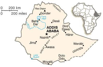
 The Federal Democratic Republic of Ethiopia is located in the north-eastern part of Africa commonly known as the Horn of Africa. It is strategically proximate to the Middle East and Europe, together with its easy access to the major ports of the region, enhances its international trade. It is bordered by the Sudan in the west, Somalia and Djibouti in the east, Eritrea in the north and Kenya in the south. The country covers 1,112,000 square kilometres (472,000 sq. miles) making it roughly as large as France and Spain combined and is five times the size of the UK.
From the north and running down the centre are the Abyssinian highlands. To the west of the chain the land drops to the grasslands of Sudan, to the east to the deserts of the Afar. South of Addis Ababa, the land is dominated by the Rift Valley Lakes.
Ethiopia's central plateau varies in height between 2,000 and 3,000 metres. In the north and centre of the country there are some 25 mountains whose peaks rise over 4,000 metres (13,200ft), the highest being Ras Dashen at 4,543 metres (14,538ft).

You can learn more about Ethiopia by browsing through the topics listed on the left navigation menu of this page.


